


17,1 km | 19,8 km-effort
![Tocht Te voet Kostomlaty nad Labem - [Ž] Kostomlaty nad Labem - ústí Vlkavy - Photo](https://media.geolcdn.com/t/1900/400/8043a1fa-bd2d-496a-9ca7-505e6aaabd52.jpeg&format=pjpeg&maxdim=2)

Tous les sentiers balisés d’Europe GUIDE+


Gratisgps-wandelapplicatie
 SityTrail
IGN / Geografische instituten
SityTrail World
De wereld gaat voor u open
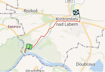
Tocht Te voet van 3,3 km beschikbaar op Centraal-Bohemen, Onbekend, Kostomlaty nad Labem. Deze tocht wordt voorgesteld door SityTrail - itinéraires balisés pédestres.
Tocht aangemaakt door cz:KČT.
![Tocht Te voet Kostomlaty nad Labem - [Ž] Kostomlaty nad Labem - ústí Vlkavy - Photo 1](https://media.geolcdn.com/t/2048/auto/ada1d94e-59a0-4bd6-b268-f3a14d47e1cf.jpeg&format=jpg&maxdim=0 "Tocht Te voet Kostomlaty nad Labem - [Ž] Kostomlaty nad Labem - ústí Vlkavy - Photo 1")
![Tocht Te voet Kostomlaty nad Labem - [Ž] Kostomlaty nad Labem - ústí Vlkavy - Photo 2](https://media.geolcdn.com/t/2048/auto/25dbab06-0062-45a5-a750-947f935ba022.jpeg&format=jpg&maxdim=0 "Tocht Te voet Kostomlaty nad Labem - [Ž] Kostomlaty nad Labem - ústí Vlkavy - Photo 2")
![Tocht Te voet Kostomlaty nad Labem - [Ž] Kostomlaty nad Labem - ústí Vlkavy - Photo 3](https://media.geolcdn.com/t/2048/auto/b17cc20d-a8d8-4abe-94ce-0bbeef3910e3.jpeg&format=jpg&maxdim=0 "Tocht Te voet Kostomlaty nad Labem - [Ž] Kostomlaty nad Labem - ústí Vlkavy - Photo 3")
![Tocht Te voet Kostomlaty nad Labem - [Ž] Kostomlaty nad Labem - ústí Vlkavy - Photo 4](https://media.geolcdn.com/t/2048/auto/6a09b7ee-266f-481d-a87c-2b36f6b0840d.jpeg&format=jpg&maxdim=0 "Tocht Te voet Kostomlaty nad Labem - [Ž] Kostomlaty nad Labem - ústí Vlkavy - Photo 4")
![Tocht Te voet Kostomlaty nad Labem - [Ž] Kostomlaty nad Labem - ústí Vlkavy - Photo 5](https://media.geolcdn.com/t/2048/auto/ba92ec45-74ea-4b71-abd5-0970462c439f.jpeg&format=jpg&maxdim=0 "Tocht Te voet Kostomlaty nad Labem - [Ž] Kostomlaty nad Labem - ústí Vlkavy - Photo 5")
![Tocht Te voet Kostomlaty nad Labem - [Ž] Kostomlaty nad Labem - ústí Vlkavy - Photo 6](https://media.geolcdn.com/t/2048/auto/ee356d1a-ce4e-4125-9591-95169bfb0a57.jpeg&format=jpg&maxdim=0 "Tocht Te voet Kostomlaty nad Labem - [Ž] Kostomlaty nad Labem - ústí Vlkavy - Photo 6")
![Tocht Te voet Kostomlaty nad Labem - [Ž] Kostomlaty nad Labem - ústí Vlkavy - Photo 7](https://media.geolcdn.com/t/2048/auto/e7a9de0d-7aee-4393-9cd2-7306ed34df10.jpeg&format=jpg&maxdim=0 "Tocht Te voet Kostomlaty nad Labem - [Ž] Kostomlaty nad Labem - ústí Vlkavy - Photo 7")
![Tocht Te voet Kostomlaty nad Labem - [Ž] Kostomlaty nad Labem - ústí Vlkavy - Photo 8](https://media.geolcdn.com/t/2048/auto/1f419ffb-4243-4526-a853-927b2ff133f1.jpeg&format=jpg&maxdim=0 "Tocht Te voet Kostomlaty nad Labem - [Ž] Kostomlaty nad Labem - ústí Vlkavy - Photo 8")
![Tocht Te voet Kostomlaty nad Labem - [Ž] Kostomlaty nad Labem - ústí Vlkavy - Photo 9](https://media.geolcdn.com/t/2048/auto/1c4361e7-8c88-44ce-9a29-6f802f1f3c16.jpeg&format=jpg&maxdim=0 "Tocht Te voet Kostomlaty nad Labem - [Ž] Kostomlaty nad Labem - ústí Vlkavy - Photo 9")
![Tocht Te voet Kostomlaty nad Labem - [Ž] Kostomlaty nad Labem - ústí Vlkavy - Photo 10](https://media.geolcdn.com/t/2048/auto/8043a1fa-bd2d-496a-9ca7-505e6aaabd52.jpeg&format=jpg&maxdim=0 "Tocht Te voet Kostomlaty nad Labem - [Ž] Kostomlaty nad Labem - ústí Vlkavy - Photo 10")
![Tocht Te voet Kolín - [Ž] Kolín - Klavary - Photo](https://media.geolcdn.com/t/375/260/85d5b99c-f882-423a-882c-3f524910e026.jpeg&format=jpg&maxdim=2)
Te voet
![Tocht Te voet Libáň - [Z] Rožďalovice - Křešice - Photo](https://media.geolcdn.com/t/375/260/cf6f4b33-7a79-43f1-85e0-975eec0c5661.jpeg&format=jpg&maxdim=2)
Te voet
![Tocht Te voet Tismice - [Ž] Přišimasy-Limuzy - Photo](https://media.geolcdn.com/t/375/260/a76d8240-31e0-4986-95fd-91655191eb60.jpeg&format=jpg&maxdim=2)
Te voet
![Tocht Te voet Říčany - [Č] Klánovice-Říčany - Photo](https://media.geolcdn.com/t/375/260/36b25a87-32ce-40a2-8108-57863b37210a.jpeg&format=jpg&maxdim=2)
Te voet
Te voet
![Tocht Te voet Říčany - [Z] Říčany - Strašín - Photo](https://media.geolcdn.com/t/375/260/097096e4-f5aa-4357-9c89-5bc1327d8251.jpeg&format=jpg&maxdim=2)
Te voet
![Tocht Te voet Mukařov - [Ž] Sv.Donát - Mukařov - Photo](https://media.geolcdn.com/t/375/260/bbc687d4-21c3-4dc3-b6bb-6878136b19e5.jpeg&format=jpg&maxdim=2)
Te voet
Te voet
![Tocht Te voet Kostelec nad Černými lesy - [Ž] Kostelec nad Černými Lesy - Doubravčice - Photo](https://media.geolcdn.com/t/375/260/36dfff77-718a-4c1c-873d-a95e35b145f6.jpeg&format=jpg&maxdim=2)
Te voet